J2Ski Snow Report - February 15th 2024
J2Ski Snow Report - February 15th 2024
Published : 15-Feb-2024 20:21

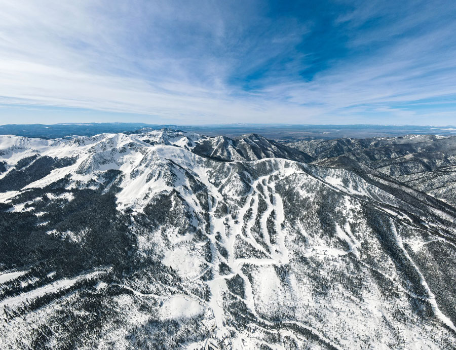
Taos Ski Valley, New Mexico, USA; snowy in the sunshine.
Still warm, but cooling, in the Alps, after some snow top-ups. Mixed conditions across America, from not much to some great powder skiing in favoured spots.
The Snow Headlines - February 15th
- Snowfall in the Alps and Pyrenees; a refresh for most, as much as 50cm.
- Montana ski area ends season early as ski areas in Pacific Northwest struggle.
- Alpine Ski World Cup back in Andorra after missed French/German weekend.
- Some ski areas in Western Canada report around 30cm this week.
- Bulgaria stages World Cup GS on Saturday but Sunday's slalom rained off.

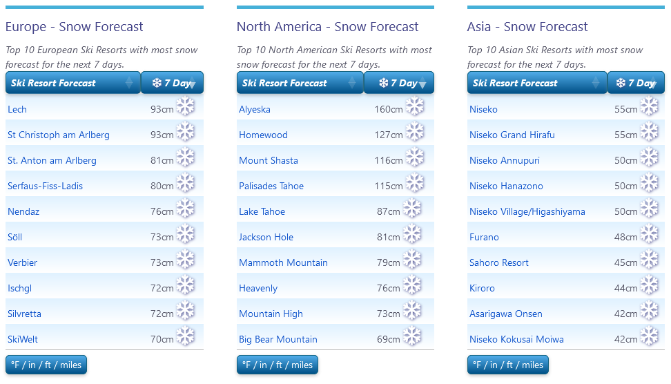
More snow forecast for Europe, USA and Japan
Re-publication :- our Snow Report Summary, being the text above this line, is free to re-publish, but must be clearly credited to www.J2ski.com with text including "J2Ski Snow Report" linked to this page - thank you.
World Overview
The forecast heavy snowfall across the Alps didn't really materialise, at least not to the extent hoped, although some areas did at least see some fresh snowfall to refresh their hard-packed slopes.
Some resorts in the southwestern Alps have accumulated as much as half a-metre of fresh snow in the last seven days. Most haven't had enough to really reboot freeriding opportunities, the upside of which is that the avalanche danger remains at 1-2 (low) on the scale to 5 almost everywhere.
Unfortunately, we're back to warm temperatures in valleys but the weather is more changeable than it was for the previous three weeks and more snow showers are forecast, with cooler weather also imminent.
The Pyrenees also saw snow, and conditions are improving in Scotland and remain excellent in Scandinavia, however, Bulgaria was hit by torrential rain at the start of the week, damaging the snowpack.
It's been a quieter week for snowfall across North America after the big dumps in California and the Southern Rockies in previous weeks. There has been plenty of sunshine but light snowfalls reported in many areas refreshing cover.
Europe
Austria
Austrian ski areas have seen some good snowfalls this week, with bases on higher slopes at resorts including St Anton, the Kitzsteinhorn Glacier and Solden up 20-30cm at the top of the slopes.
There's also been snow down to the valley floor at times, but base depths are still dropping in many areas because although there have been cold spells, we're still seeing mostly warm weather, close to 10C in valleys, and so the thaw continues.
Most slopes remain open but snow conditions remain 'sub-optimal' on low runs as soon as the fresh snow gets packed in. More light snow showers are forecast but so is warm sunny weather.
Go high for the best conditions!
France
There have not yet been quite the snowy conditions we were hoping for a week ago in the French Alps, but most areas have seen some snowfall and conditions are greatly refreshed on the hard-packed pistes.
There was snow down to the valley floor at the weekend with low-lying resorts like Les Gets posting 10cm of new snow on snow-starved lower runs, although it didn't last long away from prepared runs.
Most of the country's ski slopes are open and with the half-term holidays underway the main concern is slope safety due to crowded runs in places. Temperatures remain sub-zero most of the time at altitude and more unsettled weather and snowfall are forecast this weekend.
Italy
Italian ski areas saw some of the best snowfalls last weekend with resorts in the Dolomites reporting 20-30cm of snowfall and some decent dumps for resorts that had not had so much previously in the Western Alps too, including the Milky Way (Via Lattea) resorts like Sauze d'Oulx and Sestriere.
However, it's Cervinia that has posted the biggest base-depth increase, up 20cm at resort level, and 50cm at plateau Rosa, from last week's numbers.
Conditions are now similar across the country, back to mostly sunny skies, occasional snow showers and too warm in valleys. Hopefully forecast light to moderate snowfalls over the coming week will materialise as forecast.
Switzerland
Swiss resorts have had some fresh snow earlier this week before temperatures rose again, particularly in the valleys, meaning some saw snow down low too.
Base depths on upper runs climbed 10-20cm on a week ago – whilst valley stats remained unchanged or declined slightly. So essentially the fresh snow has refreshed cover but not made a huge difference down in valleys, while up high everything was open anyway.
Verbier and the 4 Valleys continue to post the best numbers, with about 98% of their 410km of slopes open.
The forecast is for further light-to-moderate snow showers, but staying quite warm below 1500m altitude
Scandinavia
Scandinavian ski areas remain in great shape after storm Ingunn blew through over a week ago.
More cold and snowy weather has followed in its wake, and with daylight hours rapidly increasing, there are reports of fresh powder and everything open across the region.
Snow depths are up to two metres at centres in western Norway with ski areas near coastal Voss posting the biggest numbers.
The Folgefonn (Fonna) glacier, which will open in mid-spring, says it has 10 metres of snow lying there, burying the drag lift!
Pyrenees
Finally, there has been some change to the warm weather that's been dominating the Pyrenees all season.
Although it was rather short-lived, with sunshine and warmer temperatures returning after the weekend, Soldeu in Andorra successfully hosted the Women's Alpine World Cup Races on Saturday and Sunday showing fresh snowfall down to the valley floor.
Most areas, in the end, received 20-40cm of snowfall before the sunshine returned. It's not made a huge difference to the open terrain, typically 40-70% at most areas in the region, but has been a great slope refresh.
Conditions are getting more unsettled again with snow (possibly rain at lower altitudes) forecast.
Scotland
Following weeks of storms, bringing gales and at times torrential rain, Scottish centres have finally had a fairly calm weather week. Of course, it's half term in Scotland and England so the hope was to have a lot of terrain open but unfortunately that's not the case. There is more than just nursery slope areas open at most and there's been more snowfall, particularly on higher slopes, in recent days.
Cairngorm has its nursery area (lift tickets were sold out in advance for the full week) and a return of hike-to terrain above for good skiers.
Glenshee has its nursery slopes and limited terrain beyond. The Lecht was just nursery slopes at the time of writing.
Nevis Range re-opened on Thursday 15th for the first time in nearly a month. Glencoe has about the most terrain open, more than 10 runs, although some of that terrain is best suited to good skiers.
Eastern Europe
It was bad news for Bulgarian ski areas at the start of this week with torrential rain first causing the cancellation of the World Cup Slalom racing at Bansko on Sunday and then Pamporovo reporting it was shut down for safety reasons on Monday as the rain there washed away snow cover and the storm even brought lightning strikes damaging lift towers.
Further north, rain has also put a dampener on the Biathlon World Championships taking place in the Czech Republic, but there has been snowfall higher up and Slovakia's Jasna has reported fresh snowfall this week.
In Bulgaria, the weather has stabilised and returned to sunnier skies but is now a little warm again, unfortunately with little change in the forecast.
North America
Canada
Conditions in Western BC remain challenging with Cypress Mountain and Vancouver Mountain north of Vancouver both still hardly open.
Temperatures have dipped a bit and Whistler Blackcomb says it has had over a foot of snow in the last week. It's 75% open with the best conditions up high.
Conditions improve the further east you go and into BC then over into Alberta, with resorts around Banff saying they're now 100% open, or thereabouts. It's a similar story in Quebec in the east which has seen much colder weather than the west of the country, down below -10C.
USA
It has been a quieter week across the US after the big snowfalls in the southwest last week.
The snow has kept falling, on and off, with temperatures also mostly remaining below freezing, but it has been a few inches here and there rather than any big dumps. That's the forecast for the coming week too – plenty of sunshine but also light snowfalls delivering an inch or two more snow each time.
As slopes are mostly fully open that's fine really, the Pacific Northwest is the region that's still suffering the most from below-average snow cover – Crystal Mountain in Washington State is still only at 60% open for example - but most other regions are fully open, or nearly so.
Join the conversation : Discuss this in the J2Ski Forum
This news item has been viewed 6,567 times.
Also on J2Ski :- Les Gets Snow Forecast Ski Hotels Ski Hire Ski Holidays