J2Ski Snow Report - January 9th 2025
J2Ski Snow Report - January 9th 2025
Published : 09-Jan-2025 20:08

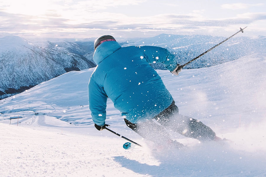
Myrkdalen, Norway, one of many ski areas with fresh this week...
More snow for Scandinavia, Europe and America. Fluctuating temperatures, and variable weather, in the Alps but base depths growing at altitude.
The Snow Headlines - January 9th
- Rain and snowfall in the Alps, higher base depths increasing.
- Avalanche risk levels also up, hitting 4/High in Western Alps, 3/Considerable elsewhere.
- Coldest temperatures in a decade in Scotland, but not enough snowfall yet.
- Scandinavia has a cold and snowy week with more terrain opening.
- Snowy week for much of North America too with reports of up to two feet in three-days.

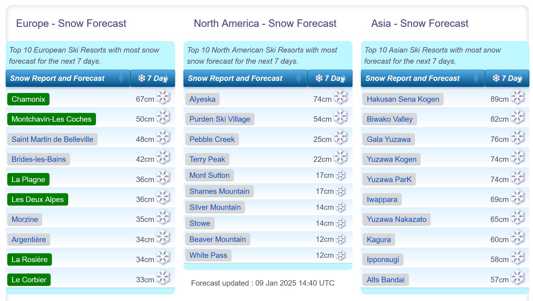
Snow forecasts worldwide.
Re-publication :- the J2Ski Snow Report Summary, being the text above this line, is free to re-publish, but must be clearly credited to www.J2ski.com with text including "J2Ski Snow Report" linked to this page - thank you.
World Overview
Things have turned more wintery in both Europe and North America this week with significant snowfall reported again in the Alps and the Rockies along with quite a few other mountain regions.
Northwestern, East Coast and Midwest North America have all seen heavy snow, as have Scandinavia and Northeastern Europe. Temperatures have plummeted below -10C and bases are building in Scotland again too.
Japan's ski areas are continuing to post the deepest snow in the world, with several centres having reached 4m and the snow still dumping there.
Temperatures have been variable in the Alps with rainfall as high as 2,500m this week, but conditions have cooled today. The outlook is for a snowy weekend coming up, probably followed by clear and dry conditions into the next week or so. Colder in the East (Austria and Switzerland, particularly).
Europe
Austria
Austrian ski regions are close to full operations after a week of mixed rainy and snowy weather.
Valley temperatures dropped below freezing again at the start of the weekend and snow started falling, heaviest on higher slopes in the north and west, but continuing across the country.
The big regions including Ischgl's Silvretta pass, the Skiwelt around Soll and Ellmau, The Arlberg with St Anton and Lech and next month's Alpine skiing World Championships hosts Saalbach-Hinterglemm are all at 80-95% operations with some areas like Obertauern and Mayrhofen fully open.
France
The French Alps have seen some of the heaviest snowfalls of the last week with reports of up to 60cm (two feet) in 72 hours on higher terrain last weekend, the freezing point down below 500m altitudes (so snow to the valley floors).
However midweek temperatures climbed well above freezing to high elevations and snow changed to rain giving poor conditions. There have also been strong winds at times, driving the avalanche danger up to high (level 4) earlier in the week, although it's now back down to 3.
Most centres already had most of their terrain open for New Years week with the 3 Valleys at 550km of slopes open around Courchevel, Meribel, Les Menuires and Val Thorens. The Portes du Soliel including Morzine, Les Gets, Chatel and Avoriaz is not far behind.
Italy
Italy has had a colder week with overnight lows on high slopes getting into double digits sub-zero and many areas staying below freezing down to the valley floor, even in the afternoons.
Along with great snow-making conditions, there's also been some fresh natural snowfall, as usual this winter heaviest in the north and west, with ski areas in Trentino posting the deepest snowpacks at more than 1.5m, but now there's some snowfall further east too.
The area incorporating Val Gardena and connected around the Sella Ronda has the most terrain open in the country, about 400km. The Milky way in the West has around 300km of pistes open.
Switzerland
Western Swiss ski areas started to see snowfall return after a dry nine-day period at the end of last week.
Again, conditions had already been pretty good across the north and west of the country in particular, but warmer temperatures between Christmas and New Year did have quite a heavy impact on snow depths, with drops of up to 80cm reported in just seven days.
Most Swiss resorts have 70-90% of their slopes open and the 4 Valleys reports 320km (200 miles) of runs, the most in the country, open around Verbier and its neighbours.
As elsewhere, mid-week saw rain for a time to quite high elevations.
Scandinavia
Things are continuing to move in the right direction in Scandinavia with the region's largest resorts progressively opening more terrain and temperatures now well below freezing (-2C to -20C commonly).
Sweden's Are, the biggest single ski area in Scandinavia, has the most terrain open of the bigger resorts, up to about 70km now, 75% of its terrain.
The heaviest snowfall continues to be in Western Norway where resorts like Voss and nearby Myrkdalen have reported up to 40cm accumulations in 24 hours delivering some deep powder conditions.
Pyrenees and Spain
The Pyrenees saw colder temperatures and some fresh snowfall this week too, but the region could do with quite a bit more of the same to really get up to full operations, as it's still not fully on track after the warm, dry autumn.
The big areas like Andorra's Grandvalira (Pas de la Casa, Soldeu etc) and Spain's Baqueira Beret are around 70% open and most resorts on the French side are in a similar position too.
On the Spanish side some resorts including Cerler and Formigal only have around 30% of their trails open.
Sierra Nevada, in the south, has similarly limited terrain open but did get a 35cm fall, improving things a lot, midweek.
Scotland
Much colder temperatures in Scotland this week, below freezing and actually getting down to -10C and below to end the week.
Quite a lot of clear skies but also some snow showers so bases are building again.
The four centres with all-weather snowmaking machines (Glencoe, Glenshee, Cairngorm and The Lecht) continue to operate limited terrain but hope to open more due to ongoing sub-zero temps.
Unfortunately temperatures are forecast to rise at the start of next week.
Eastern Europe
A good week for eastern Europe as well, with powder days reported for ski areas in countries in the north including Czechia, Slovakia and Poland.
Spindleruv Mlyn in the Czech Republic had an especially snowy start to the week.
It's been drier with plenty of sunshine further south in Bulgaria and most of the Balkans but most areas are fully open from earlier snowfalls with Bansko still posting the deepest base in the region, now approaching 2 metres up top, after posting the biggest snowfall in Europe during the sunny-almost-everywhere-else Xmas-New Year week.
North America
Canada
Canada has had a week of consistently cold temperatures, with ski areas across the country posting numbers in the -10C to -20C range.
The East Coast had largely dry weather for the resorts of Quebec, Ontario and neighbouring provinces, whilst on the western side of the country ski areas in Alberta and British Columbia saw more significant accumulation keeping the powder deep.
The result is great conditions at most ski areas across BC with centres including Big White, Fernie, Silver Star and Sunshine reporting their slopes 100% open and the snow lying up to 2 metres deep.
In the East, only Tremblant is looking pretty good with two thirds of its runs open; most other centres have less than 40cm lying and only 20-40% of their slopes available after a challenging season start.
USA
The big storm (christened Blair) that hit the US at the start of the week was most noteworthy for bringing rare snowfall to southern states which rarely see any, but, combined with a Polar Vortex moving down from the north, was also good news for ski areas in New England and the Midwest which are still battling to open even half their terrain after the warm autumn.
The best conditions continue to be in the north and west in states like Idaho and Oregon where centres are fully open and base depths up to 3 metres. The Rockies saw good snowfalls too, with Utah's Snowbird reporting snow falling at up to 10cm (4 inches) per hour at one point.
Join the conversation : Discuss this in the J2Ski Forum
This news item has been viewed 6,765 times.
Also on J2Ski :- Morzine Snow Forecast Ski Hotels Ski Hire Ski Holidays