J2Ski Snow Report - February 27th 2025
J2Ski Snow Report - February 27th 2025
Published : 27-Feb-2025 19:31
Saalbach Hinterglemm Leogang Fieberbrunn, Austria, this week...
Seven metre snow depths in Japan, sunshine (and fresh snow in places) for Europe and a snowy week in NW North America.
The Snow Headlines - February 27th
- First ski area in the world to reach a 7-metre base depth this winter is in Japan.
- Snowiest week in February for North America's Pacific Northwest corner.
- Deepest snow depths in the US up 50% in past few weeks to 4.5m (15 feet).
- New snow freshens things up nicely for some European slopes, sunshine elsewhere.
- Mild temperatures wipes out thin snow cover in Scotland.
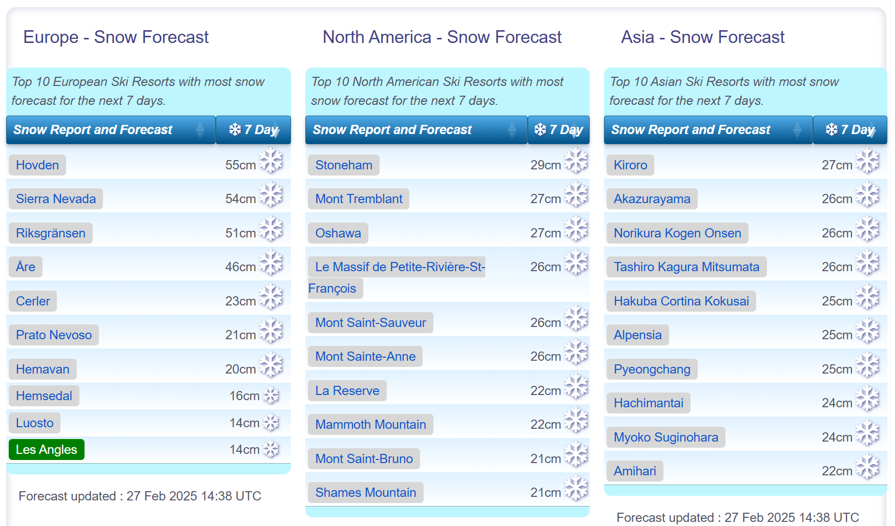
Snow forecasts worldwide.
Re-publication :- the J2Ski Snow Report Summary, being the text above this line, is free to re-publish, but must be clearly credited to www.J2ski.com with text including "J2Ski Snow Report" linked to this page - thank you.
World Overview
Conditions have turned quite changeable across Europe this week as we move into springtime (by the meteorological measure of the seasons). Dry weather last week was punctuated by weak fronts moving in, bringing light to moderate snowfall, particularly in the Pyrenees and southern and western Alps.
Temperatures have inevitably been creeping up, and it is now rather warm in the afternoon in valleys, pushing the snowline up and meaning precipitation is falling as rain at times, at least at lower levels.
North America has seen the bigger snowfalls, again, although not so big as in recent weeks. The Rockies got snow up to the weekend but it's been warmer and drier since. It's the Pacific Northwest corner (Oregon, Washington State, Alberta and BC) that has seen the best of it, picking up more than half a metre of snowfall in the best cases delivering powder conditions.
That continues to be the case across the Pacific too, with more Japanese ski areas passing the six-metre base depth mark after more heavy snowfall and the first there this season (and for several seasons) reaching 7 metres.
Europe
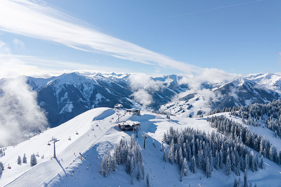
Austria
Austria has had a week of mixed weather, with spells of sunshine, low clouds, and light snowfall, and some resorts seeing slightly more substantial 5-10cm accumulations in recent days.
It's been fairly mild too, considering it's still February, with valley highs reaching +10C in afternoons, pushing the snowline further up valley sides, although pistes are being maintained down to base levels.
Most Austrian ski areas remain fully open with the Arlberg region including Lech and St Anton reporting the largest area open in the country - almost 300km.
France
French ski areas had a slightly snowy start to the week as fronts moved up from the Mediterranean bringing light to moderate snowfall, most notably above about 2,000m. Warmer weather at lower altitudes meant some saw rainfall at times.
High altitude areas like Les Arcs and La Plagne posted 30-40cm accumulations in total over the first half of this week.
Skies are starting to clear now though with sunnier weather and slightly cooler temperatures expected for the final days of February and the start of March.
Italy
A bit of a holding pattern in Italy with little change on conditions a week ago. It has been warmer at resort bases, getting as high as +12C in the afternoon down in valleys but the past few days have brought lower temperatures, low cloud and some light snowfall. Slopes up above 2,000m have seen the most (10-20cm) accumulations, but for most areas it has been more like 5-10cm.
Although warmer during the day, overnight lows have enabled snowmaking systems to keep operating. The coming week looks like its back to sunshine and increasingly warm temperatures however.
Switzerland
Swiss centres have enjoyed snowfall, heaviest in the west, over the past few days.
Accumulations of up to 30cm were reported for ski areas including Crans Montana, Leysin and Saas Fee. The snow arrived after a rather murky start to the week with warm temperatures leading to hill fog and a bit of a thaw, especially at lower levels.
Most Swiss ski areas remain fully open with Verbier and the 4 Valleys and the Zermatt-Cervinia region posting the most terrain available. Skies have started to clear now and it looks like a sunny weekend ahead and continuing so next week, with temperatures rising after a cold few days.
Scandinavia
A better week, on the whole, across Scandinavia with some light-moderate snowfalls that actually got heavier than normal for the region (up to 35cm reported in 24 hours) on Monday.
However, temperatures have been getting above freezing and there have been reports of rain rather than snow at times on some lower slopes.
Norway's Voss was one of the ski areas doing particularly well for snow, reporting more than 50cm of snowfall this week, although it was also one of those reporting rain at lower levels on occasion.
It's looking a little drier for most areas through the weekend.
Pyrenees
After last week's largely dry, sunny weather with warmer temperatures, it's been a much better period of colder temperatures and light to moderate snowfalls since the weekend in the Pyrenees.
There have not been any huge snowfalls but enough to give slopes a nice refresh and stop the depth stats from their freefall. Andorra's Grandvalira (Pas de la Casa, Grau Roig, Soldeu, El Tarter et al) continues to post the most terrain open, about 185km or 85% of its slopes, the most it's had open all season.
Scotland
Scotland is enjoying or enduring (depending on how you look at it), its familiar pattern of snowfalls followed by warm spells preventing base depths from building on the mountains like they used to. There have been some long, sunny, cold spells but they've tended to happen when there's little snow lying, not after the bigger falls.
Four centres (Glencoe, Glenshee, Cairngorm and The Lecht) have some terrain open thanks to all-weather snowmaking machines. Nevis Range doesn't have one and is yet to open this season.
It's looking fairly promising for hill snow, Glencoe reported 15cm on Wednesday, but the forecast is looking warmer and drier over the coming days.
Eastern Europe
A fairly dry week in Eastern Europe too, although temperatures have actually been a few degrees cooler in the Balkans, as well as further north in countries like Czechia, Poland and Slovakia.
Here too, most ski areas are fully open. Resorts in Bulgaria are posting some of the best snow depth stats in Europe, touching 2 metres at Bansko and Borovets.
The week ahead looks similar, just slightly warmer, with plenty of sunshine and just occasional light snowfall.
North America
Canada
A big week in western Canada with some of the best snowfalls this month in what had been a very cold but relatively dry February. Ski areas here are reporting up to 50cm of snowfall since Saturday.
Big White, Lake Louise and Whistler are among the resorts to report 30cm of snowfall in the last 72 hours and powder conditions.
It remains good over on the east coast too, with temperatures still dipping down to the -20s there and all terrain open.
USA
Mixed conditions across the US this week with the heaviest snowfall reported in the country's Pacific Northwest corner in states like Oregon and Washington.
Unfortunately, although higher slopes got more than a foot of snow, lower runs saw rain at times and there have also been very strong winds in the region, so much so that several ski areas in Oregon were closed on Tuesday-Wednesday.
There's been some lighter snowfall in the Rockies but also warmer weather - and bases have actually dropped a little here whilst rising in the north of the region.
Overall conditions are pretty good across the country with most resorts still fully open.
Join the conversation : Discuss this in the J2Ski Forum
This news item has been viewed 41,715 times.
Also on J2Ski :- Les Arcs Snow Forecast Ski Hotels Ski Hire Ski Holidays