J2Ski Snow Report - March 12th 2026
J2Ski Snow Report - March 12th 2026
Published : 12-Mar-2026 20:04
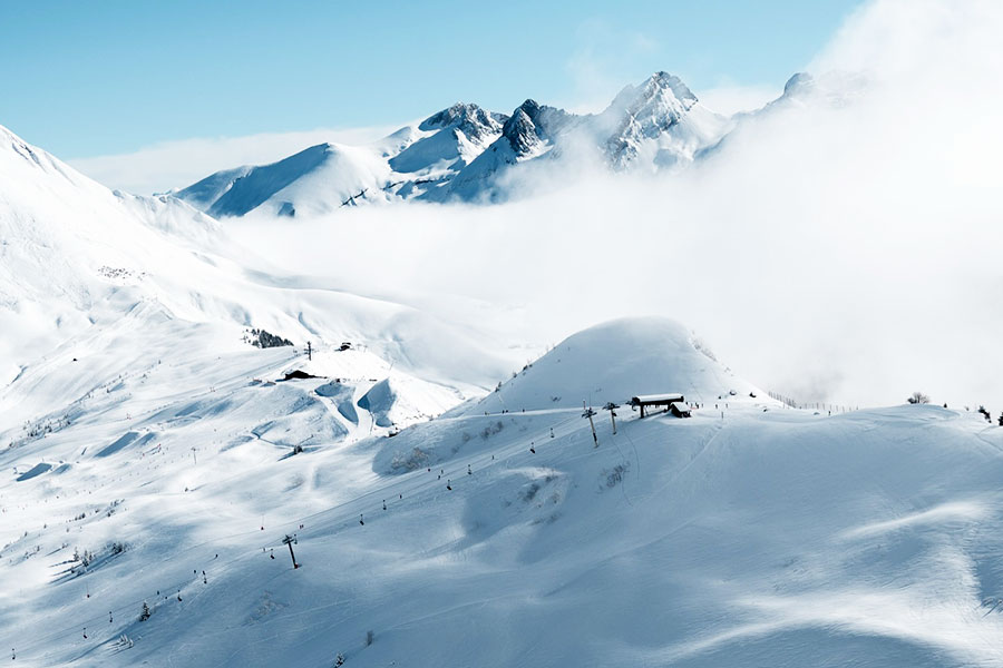
Le Grand Bornand, France: it may have felt like spring but winter clouds are rolling back in....
This week switches back to winter in the Alps as temperatures fall and snowfall arrives over the coming days. There has been fresh snow in parts of North America and Europe, and there is deep upper-mountain snow in Scandinavia and the Pyrenees.
The Snow Headlines - March 12th
- Significant weekend snowfall is forecast to end a three-week mostly dry spell in the Alps.
- US Rockies see up to 90cm/35 inches (most 10–30cm/4 inches to 12 inches) snowfalls.
- Snowfall in south-western Europe delivers up to 25cm/10 inches of snow to the Pyrenees and SW Alps.
- Milder weather reaches the North American East Coast, ending a three-month sub-zero run.
- Alpe d'Huez back to a 4m/13 feet base, Europe's deepest, after Thursday snowfall.
- The Lecht is the second Scottish area to close for the season unless there is a late snowfall.
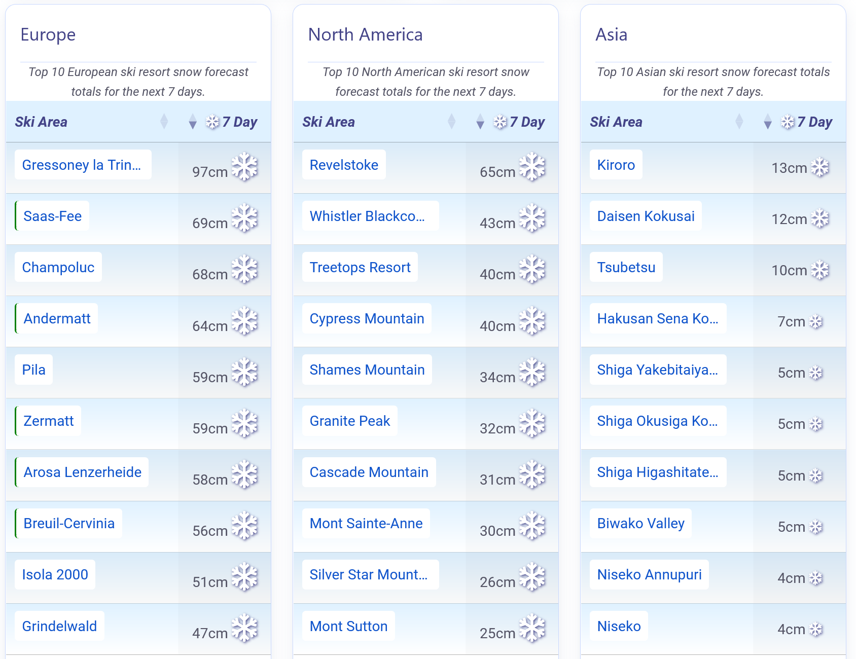
More Snow forecast for the Alps, America and Japan.
Re-publication :- the J2Ski Snow Report Summary, being the text above this line, is free to re-publish, but must be clearly credited to www.J2ski.com with text including "J2Ski Snow Report" linked to this page - thank you.
World Overview
A third straight week of sunshine for much of the Alps has left most of Europe in classic spring mode, with bright skies and mild afternoons pushing valley temperatures towards +15°C/59°F while higher slopes remain close to freezing. However a marked change is expected over the next few days as temperatures drop and snowfall spreads, with some areas likely to see as much as 60–90cm/24 inches to 35 inches on higher ground by Monday.
This week has already seen a subtle shift, as weak fronts from the southwest reintroduced showers to the Pyrenees and the southern French Alps. Saharan dust has also drifted north again, creating hazy light and leaving a fine orange film on some pistes.
Scandinavia remains Europe's wintry outlier, holding sub-zero temperatures across the north and east and delivering the continent's most regular snowfall, particularly in Norway.
Across the Atlantic, spring conditions dominate in parts of North America despite a brief return to colder, snowier weather in the Rockies.
In Japan, a colder pattern returned fresh snow to Honshu's higher mountains at the start of the week after a milder spell.
Europe
Austria
The Austrian Alps are in a third week of largely dry, springlike weather, with sunshine common and valley temperatures climbing to 10–18°C/50°F to 64°F. Higher up, mid-mountain levels hover between -5°C/23°F and +5°C/41°F, while glaciers stay cold with sub-zero conditions and the best snow cover.
Lower resorts, including the Kitzbüheler Alpen, SkiWelt and Saalbach Hinterglemm, continue to see freeze–thaw cycles that soften slopes by midday. Light rain, sleet or snow showers have been reported, but new accumulations have been minimal.
The coming week looks a little colder with more significant, if not huge, snowfall forecast for higher ground.
France
Springlike conditions have continued across the French Alps, with mild valleys and colder weather higher up. The southern Alps finally saw some snowfall, with totals below the forecast 20–50cm/8 inches to 20 inches except in Isola 2000, which reported 25cm/10 inches on Wednesday, and Alpe d'Huez which added 26cm/10 inches, taking it back up to 4m/13 feet, Europe's deepest snowpack.
High‑mountain areas such as Tignes–Val d'Isère and the 3 Valleys still hold substantial cover from last month's big falls, despite settling from earlier peak depths. Mid‑mountain temperatures range from -5°C/23°F to +5°C/41°F, while lower slopes soften by midday.
Terrain above 2,000m/6,562 feet remains the most reliable, especially north‑facing aspects. Saharan dust has been reported in places.
Things look set to change with heavy weekend falls forecast, prompting the FIS to swap Courchevel's Saturday World Cup Downhill with the planned Friday Super‑G to maximise the chances that a race can happen.
Italy
The Italian Alps and Dolomites are in classic mid‑March mode, with mild valleys now green other than maintained pistes and colder, more reliable conditions higher up. High altitude resorts such as Cervinia and Livigno offer the best conditions above 2,000m/6,562 feet, while lower slopes at other centres mostly remain open with daily freeze–thaw cycles. High terrain generally holds firm, dry snow thanks to predominantly sub-zero temperatures.
The Via Lattea currently offers the most linked terrain in Italy, with 85% (about 340km/211 miles) of runs open.
It has started snowing in the last few days with Aosta Valley resorts reporting 10cm/4 inches on Wednesday and the weekend could bring as much as 90cm/35 inches accumulations on high ground along the French and Swiss borders.
Switzerland
Across Switzerland, the shift toward spring is increasingly defined by altitude. High, glacial resorts such as Zermatt, Saas‑Fee, Engelberg and Andermatt continue to deliver the most reliable conditions, with upper‑mountain snow depths of 150–230cm/59 inches to 91 inches and consistently cold temperatures. Below 2,000m/6,562 feet, pistes start firm before softening into spring snow each afternoon, while lower slopes show thinning cover after repeated freeze–thaw cycles.
North‑facing high‑alpine terrain above 1,800m/5,906 feet remains the strongest option for quality skiing.
There's been some light snowfall reported and a more active weather system is expected to arrive at the weekend, hopefully bringing heavier snow above 1,500m/4,921 feet. Zermatt and Saas‑Fee are among areas expected to see 60cm/24 inches (2 feet) or more by the start of next week.
Scandinavia
Scandinavia remains Europe's most reliably wintry region as we move further into March, with Norway, Sweden and especially Finland still locked into sub-zero conditions. Snow cover is widespread, trees remain frosted, and several areas have reported fresh snowfall this week.
Norwegian resorts again lead the continent for new snow but in northern Sweden, Riksgränsen reported 10cm/4 inches at the weekend having recently begun its 2026 season. Sunshine has dominated between snow flurries, but temperatures have stayed cold overall, with overnight lows down to -10°C/14°F or even -15°C/5°F in the north and east, and daytime highs near -5°C/23°F further south.
Pyrenees
After a bright period last week, the Pyrenees saw more mixed weather to start this week, with passing snow showers, low cloud and occasional snowfall depending on elevation. The pattern has now shifted back to settled, sunny weather, with mild afternoons and high freezing levels, but a return to colder, snowier conditions looks possible early next week.
Major resorts including Baqueira Beret, Grandvalira, Formigal and Saint‑Lary continue to hold impressive upper‑mountain depths of around 200–350cm/79 inches to 138 inches, among the deepest in the world, though day‑to‑day conditions vary as sleet and light snow drift through. Freeze–thaw cycles remain a feature, influencing surface quality and visibility. Despite the changeable conditions, most pistes across the region remain open.
Scotland
Scotland's ski centres have faced a familiar mix of mild afternoons and passing showers, with new snowfall mainly at higher elevations.
Nevis Range remains closed, and The Lecht had planned to reopen with limited terrain after closing on Monday and Tuesday but announced on Wednesday it was instead closing for the season unless cold, snowy weather returns. Cairngorm, Glencoe and Glenshee have seen fresh snowfall overnight, mostly on their upper mountains. Gales have closed slopes over the past few days. Glencoe advises conditions are best for confident intermediates and better skiers and riders.
Unsettled Atlantic weather continues to bring rain, sleet and hill snow. Periodic snowfall is expected to continue above mid‑mountain level in the Highlands, though strong winds may disrupt uplift.
Eastern Europe
Spring has taken firm hold across Eastern Europe, with temperatures swinging between -10°C/14°F and +10°C/50°F and the freezing level fluctuating from 1,000 to 1,500m/3,281 feet to 4,921 feet. Bulgarian resorts have enjoyed near‑uninterrupted sunshine, yet Bansko continues to offer top‑to‑bottom skiing even as lower‑mountain cover thins to just 10cm/4 inches.
In Slovakia, Jasná leads the region with 90% of its terrain open. A cooler spell is expected to end this week, though conditions stay largely dry. Light winds, bright skies and a consolidating snowpack will dominate, keeping most Carpathian ski areas fully operational.
North America
Canada
Western Canada has seen a mix of mild spells and fresh snowfall, with most resorts picking up light accumulations of 5–10cm/2 inches to 4 inches although there have been some more significant falls, notably Banff's Sunshine posting 30cm/12 inches to start the week.
Upper‑mountain temperatures remain consistently below freezing, though base levels have nudged up to +4°C/39°F to +8°C/46°F at times. Whistler Blackcomb continues to offer 95% of terrain, the most in North America, while Revelstoke maintains the country's deepest snowpack. A run of Pacific systems has brought further light to moderate snow across British Columbia's interior and Alberta's Rockies this week, along with occasional gusty winds. The east coast has warmed up considerably with some rain rather than snow showers impacting operations at times.
USA
Sunshine continues to dominate much of the Pacific Coast, where upper‑mountain temperatures sit around freezing and bases climb into the high teens. Oregon and Washington have picked up snow, getting heavier as we publish this week's report. Inland, the Rockies enjoyed a brief powder burst of 10–20 inches (25–50cm/10 inches to 20 inches) to end last week, with one small Idaho area (Pomerelle) posting a 90cm/35 inches 24‑hour total, before warm, bright weather returned. On the East Coast, a thaw has lifted freezing levels into the plus‑teens Celsius, though overnight refreezing continues to deliver classic corn snow.
Join the conversation : Discuss this in the J2Ski Forum
This news item has been viewed 335,228 times.
Also on J2Ski :- Alpe d'Huez Snow Forecast Ski Hotels Ski Hire Ski Holidays