J2Ski Snow Report - March 19th 2026
J2Ski Snow Report - March 19th 2026
Published : 19-Mar-2026 18:09

Crans Montana, Switzerland, skiing well this week...
There's been a return to wintry conditions with some decent snow in parts of the Alps last weekend and heavy falls across North America's Pacific Northwest. It has been warm in parts of the western USA, while there are deep bases in the Pyrenees and Bulgaria, and spring conditions elsewhere.
The Snow Headlines - March 19th
- Up to a metre/39 inches of weekend snowfall in the Alps.
- Record warmth in western USA, +20°C/68°F for ski areas in California and Colorado.
- Up to a metre/39 inches of snowfall in America's Pacific Northwest.
- Scottish centres got fresh snowfall but spent most of the past week stormbound.
- Upper base depth tops 2m/79 inches at Bulgaria's Bansko after fresh snows up high.
- Base depths around 3m/118 inches on upper slopes in the Pyrenees - best for spring in years.
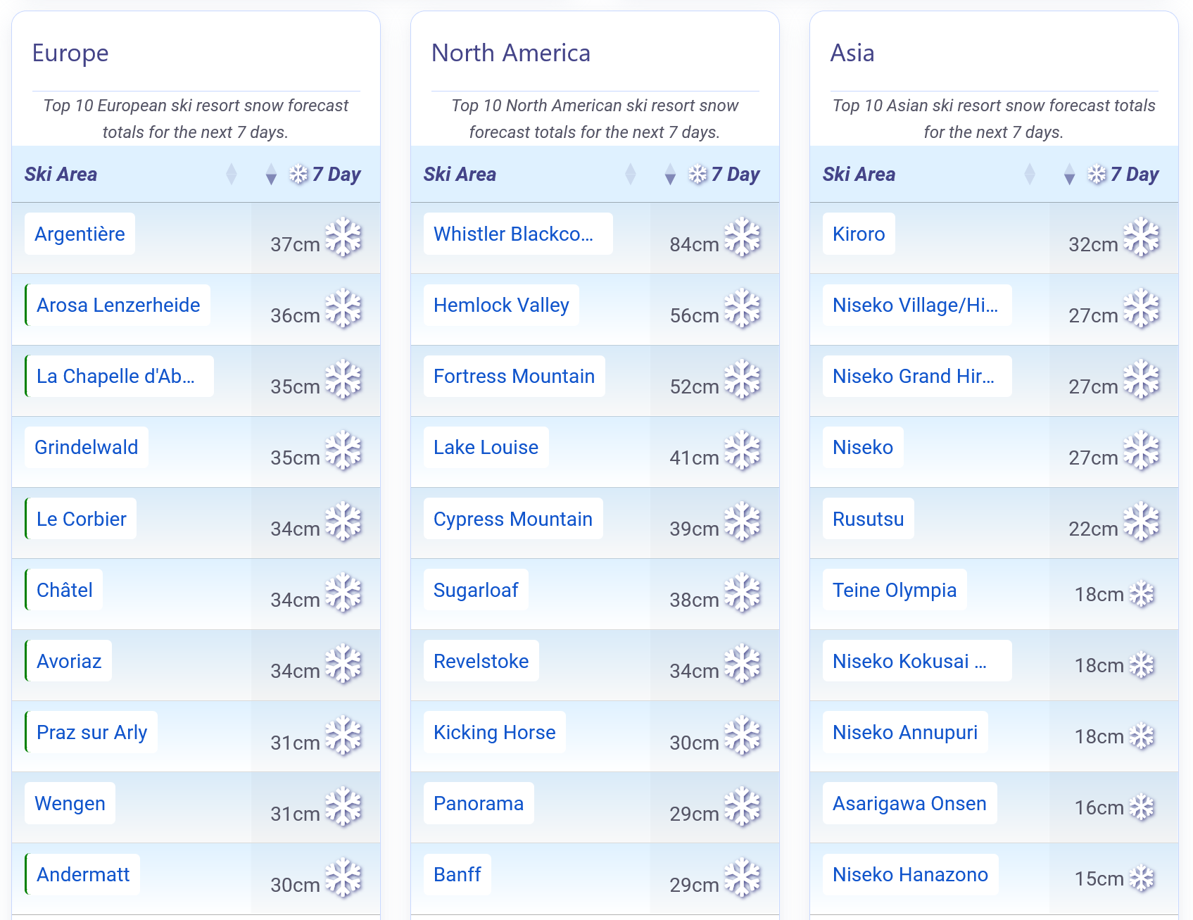
Snow forecast for the Alps, America and Japan.
Re-publication :- the J2Ski Snow Report Summary, being the text above this line, is free to re-publish, but must be clearly credited to www.J2ski.com with text including "J2Ski Snow Report" linked to this page - thank you.
World Overview
We're fast approaching the start of 'full spring' when astronomical springtime joins meteorological springtime, which we've been in all month.
After weeks of fairly springlike weather, the past seven days have seen winter return, with ski regions on both sides of the Atlantic posting up to a metre/39 inches of snowfall. In North America it was the northwest corner of the continent that saw the heaviest snowfall, while in Europe the western Alps recorded the largest totals.
'Springlike conditions' are never far away in most areas, and after slopes are refreshed by the new cover many expect a return of mild, dry weather and freeze‑thaw conditions. The exceptions to that are Scandinavia, inland Canada and parts of the Scottish Highlands, where it has stayed colder and wintry for much of the past week.
Europe
Austria
After recent dry weeks, Austria has enjoyed a notably snowy spell this week, with glaciers including at Solden and the Stubai receiving up to 50 cm/20 inches of new snow and most resorts seeing 15–30 cm/6 inches to 12 inches of fresh. Although totals were lower than in the western Alps, it has provided a valuable late‑season reset.
The Arlberg, including Lech and St Anton, now reports its best terrain coverage of the winter and powder conditions after recent top‑ups.
Austrian resorts tend to start closing from the final weekend of March, with higher areas staying open into May and some glaciers later still. The coming week looks to see a return to unsettled conditions after a sunny few days.
France
Late‑March conditions in the French Alps are lining up superbly after a stormy weekend delivered 30–60 cm/12 inches to 24 inches of new snow across higher slopes, with some resorts seeing even more. Deep February bases mean most areas are fully open and looking strong for Easter.
Courchevel topped the charts with 83 cm/33 inches, although the heavy snowfall forced the cancellation of both scheduled World Cup races at the weekend after the Downhill got under way on the Friday.
This week stays mostly sunny but colder, with summit temperatures of –10°C to –16°C/14°F to 3°F and occasional light snow above 1,600–1,900 m/62,992 inches to 74,803 inches. Conditions on higher terrain in Tignes, Val Thorens and Les 2 Alpes remain wintry, while mid‑mountain zones see mixed precipitation and brighter spells.
Italy
Northern Italy picked up significant snowfall over the weekend too, giving a great boost to ski conditions for the final month of the season.
Cervinia recorded one of the largest totals with 55 cm/22 inches, reinforcing its long spring season. Courmayeur and the wider Aosta Valley saw the first snowfalls late last week before the storm intensified and spread east, disrupting the closing days of the Paralympics in Cortina.
Sunshine has now returned, bringing classic spring skiing with crisp mornings and softer afternoons as freezing levels dip mid‑week. Higher slopes in South Tyrol, Val di Fassa and Alta Badia stay cold, while Cortina is favoured for 20–40 cm/8 inches to 16 inches of new snow in longer‑range forecasts.
Switzerland
Ski areas in the Swiss Alps posted the biggest numbers from the weekend snowfall, with Saas‑Fee topping the table with a 1 m/39 inches total. Verbier got 80 cm/31 inches so there were powder conditions at the weekend across the western Swiss Alps.
In fact, the whole country did well with St Moritz in the east also posting 70 cm/28 inches accumulation and the Jungfrau getting a much‑needed boost of snow too. Swiss centres also posted the biggest rise in avalanche danger warning levels up to level 4 after the snowfall. It's turned mostly dry and sunny here since the weekend.
Scandinavia
Spring may be arriving elsewhere, but Scandinavia remains in winter mode.
Western Norway saw up to 50 cm/20 inches of snow in recent days in Voss. Most major resorts, including Trysil, stayed below freezing with regular light top‑ups.
Sweden's Åre reported sub‑zero summit temperatures and passing squalls, and Finland remained the coldest, with Levi holding firm winter cover.
The cold spell continues across Scandinavian mountains, with –10°C to –18°C/14°F to 0°F on higher slopes and only light snow in Norway. Lapland stays very cold but mostly dry.
Pyrenees
The Pyrenees have enjoyed a largely sunny spell, allowing skiers to make the most of deep late‑season cover. Grandvalira saw shifting freezing levels bring cloud, light snow and occasional sleet, while France's Saint‑Lary‑Soulan held a strong, uniform base with only brief high‑elevation flurries. Baqueira Beret remains one of the region's standouts, combining very deep snow with regular top‑ups. The week stays mostly bright, with –7°C to –12°C/19°F to 10°F on upper slopes and milder valleys. Cloud and light snow return at higher elevations later, with lower slopes seeing sleet or rain.
Scotland
Scottish mountains were battered by storms for much of the past week with gale‑force winds closing lift access most days. Since Wednesday things have calmed for some blue‑sky skiing with fresh snow. Despite the good snow news up high, milder temperatures have impacted cover and Glenshee has joined the Nevis Range and The Lecht in closing for the season unless there's a more wintry spell.
Unlike the other two, Glenshee says it may reopen this weekend.
That leaves Glencoe and Cairngorm still open, the latter reporting Top Bowls and the White Lady and Coire Cas runs. The centre also reports their freestyle park is in excellent condition.
Eastern Europe
Eastern Europe has shifted back into a more unsettled pattern after a largely sunny, mild spell.
The Carpathians have turned wetter, with bases well above freezing and rain or sleet now common, while only the highest slopes see brief wet‑snow top‑ups.
Bulgaria remains colder, with Bansko, Borovets and Pamporovo holding sub‑zero summits but also seeing a spring mix of snowfall up high, sleet and rain.
The week ahead stays mild and changeable, with –3°C to +3°C/27°F to 37°F on mid‑mountain terrain and warmer valleys reaching 10–15°C/50°F to 59°F. Light snow may brush the Tatras mid‑week.
North America
Canada
Western Canada enjoyed a strong late‑season reset this week, led by the North Shore mountains. Mount Seymour recorded 60 cm/24 inches in 72 hours, with Cypress and Grouse mountains near Vancouver each adding around 45 cm/18 inches on their upper slopes.
Inland, Alberta and interior BC resorts also saw healthy totals, with Norquay topping 52 cm/20 inches to start the week. Cold temperatures are preserving firm, mid‑winter snow above mid‑mountain. The broader pattern remains settled and chilly, with summit temperatures between –15°C and –22°C/5°F to –8°F and lighter winds. Expect occasional light snow in the Kootenays, while the Coast Mountains see mixed precipitation and milder bases.
USA
The US West Coast is split between early closures of some smaller centres in California after a long, dry, warm season and deep new snow farther north.
Oregon's Timberline, normally open into August, logged a huge 1.2 m/47 inches fall, its biggest of the winter. Mount Baker and Mount Hood Meadows added around three feet in the same period before conditions turned milder again.
In the Rockies, most areas saw only 10–20 cm/4 inches to 8 inches and it has turned very mild there too with Colorado ski areas seeing +20°C/68°F at base level and record March warmth in Utah.
The East Coast remains the most wintry part of the country although it's milder there for the coming week too (if not as mild as the west).
Join the conversation : Discuss this in the J2Ski Forum
This news item has been viewed 591,463 times.
Also on J2Ski :- Val Thorens Snow Forecast Ski Hotels Ski Hire Ski Holidays